Parcels and zoning
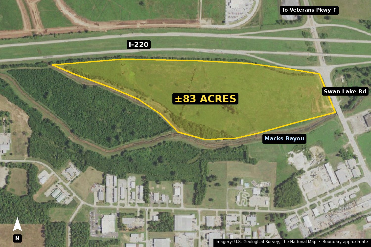
Bossier Parish Assessor · Bossier City map portalTwo contiguous parcels make up the tract. Both are already zoned for commercial use, so a buyer does not need a rezoning to build. The land is an open hay field with only a few scattered trees, so little clearing is needed before site work.
| Assessment # | Tract | Acres | Zoning |
|---|---|---|---|
| 147954 | 1813141O | 74.04 | B-3 General Business |
| 172827 | 1813151D2P | 9.11 | I-1 Light Industrial |
| Total | 83.15 |
Acreage is from assessor GIS, not a survey. Deeded acreage will be confirmed by survey. A small bayou separates the 9.11-acre I-1 parcel (west) from the 74.04-acre B-3 parcel (east), so developing them together needs an internal crossing.
Location, access and traffic
LaDOTD 2025 AADT · Google Earth measurementsFrontage Measured
The I-220 frontage provides visibility. Vehicle access is from Swan Lake Rd. The property's corner sits at the I-220 ramp to Swan Lake Rd.
Daily traffic on I-220 LaDOTD 2025
Annual average daily traffic, both directions. Stations 127420 (mile 12.25) and 128250 (mile 15.42). A current Swan Lake Rd count is pending.
Growth corridor Open
- Veterans Parkway opened in December 2024. The nearly 4-mile road connects I-220 at Swan Lake Rd to LA Hwy 162 via Crouch Rd, with new signals at the interchange.
- Barksdale AFB East Gate: a new base entrance road (LA 1267) runs south from the I-20/I-220 interchange. Barksdale has more than 15,000 active-duty and Reserve members.
Second access to Viking Dr Planned
A road and one bridge over Macks Bayou would connect the property to Viking Dr. The adjacent owner has agreed to the connection. Terms and engineering are in progress.
Coordinates: 32.555083, -93.683818 · Open in Google Maps
Best-fit uses
B-3 / I-1 zoning · DoD AICUZ guidelinesHotel
Interstate visibility near the Barksdale East Gate. Serves base visitors, contractors and I-220 travelers.
Medical office
Outpatient clinics and medical offices for the growing north Bossier and Benton area along Veterans Parkway.
Retail and service pads
Restaurants, fuel, and retail at the exit, visible to more than 46,000 vehicles a day.
Site conditions
FEMA · USFWS NWI · Bossier City map portalFlood Review in progress
FEMA FIRM panel 22015C0416D (effective 9/26/2008) shows Zone A along Macks Bayou on the south edge, with a narrow regulatory floodway at the bayou. The property did not flood in the March 2016 regional flood, when more than 18 inches of rain fell at nearby Barksdale AFB. An engineering review of the mapping is being evaluated.
Wetlands Consultant evaluating
The National Wetlands Inventory maps a 0.59-acre freshwater pond (PUBF) and a 2.02-acre riverine channel (R5UBH). About 1 acre of isolated wet area on the north side was created by past dirt work. An environmental consultant has evaluated it and expects it can be resolved through the Corps process.
Barksdale noise zone Mapped
Most of the 74-acre parcel is in the 65 dB DNL contour and the 9-acre parcel is in the 70 dB DNL contour. Department of Defense guidelines treat retail, office, medical office and hotel uses as compatible with sound-attenuated construction. Residential use is generally not recommended.
On-site fill Testing pending
A large volume of clay spoil from Macks Bayou maintenance sits on the property and can be used as site fill. Lab testing will confirm suitable uses and volume.
Abandoned pipeline Records pending
An abandoned pipeline crosses the property east to west from Swan Lake Rd. The planned entrance road from Swan Lake Rd is routed directly over it, so the line stays in place under the road and does not affect building sites. Abandonment records are being confirmed.
Ground cover Observed
Open hay field with a few scattered trees. Tree lines buffer the I-220 edge and the bayous.
Being confirmed
Updated as received- Utilities: water, sewer, electric (SWEPCO), natural gas and fiber, with distance to the nearest lines
- Boundary survey and deeded acreage
- Current traffic count on Swan Lake Rd since Veterans Parkway opened
- Driveway locations on Swan Lake Rd near the I-220 ramp (LaDOTD)
Questions investors ask
Does the property need to be rezoned for commercial use?
No. The 74.04-acre parcel is zoned B-3 General Business and the 9.11-acre parcel is zoned I-1 Light Industrial.
Where does traffic data come from?
I-220 figures are LaDOTD 2025 annual average daily traffic counts at stations 127420 and 128250. A current count on Swan Lake Rd is pending.
Is apartment or single-family development possible?
The site lies in the Barksdale AFB 65 and 70 dB noise contours, where Department of Defense guidelines do not recommend residential use. The site is marketed for commercial development.
Contact
Send a message for pricing, site plans, the full fact sheet, or a site visit.